
However, there was no report of any major damage or casualty so far even as the landfall process started more than an hour ago, the official said.

The state government has instructed officials in coastal districts and various departments to be alert to tackle any emergency situation

"Montha over westcentral Bay of Bengal moved north-northwestwards with a speed of 17 kmph during the past six hours and lay centred at 2.30 am on October 28 over the same region about 230 km south-southeast of Machilipatnam (and) 310 km south-southeast of Kakinada," said the Met Department in a release.

The Odisha government has put all 30 districts on alert as a depression over the Bay of Bengal intensified into a deep depression and is moving towards the east coast. The IMD forecasts very heavy to extremely heavy rainfall in Odisha on October 28 and 29.

The cyclonic storm is likely to move nearly westwards and cross north Andhra Pradesh-south Odisha coasts between Kalingapatnam and Gopalpur around Sunday evening, the Cyclone Warning Division of the IMD said.

The low-pressure area over the South Andaman Sea and adjoining southeast Bay of Bengal is very likely to move northwestwards and intensify into a depression by Saturday, the weather office said.

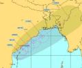
Severe cyclonic storm 'Montha' has begun making landfall off the Andhra Pradesh coast, with the process expected to continue for the next three to four hours. The storm is expected to cross the coast between Machilipatnam and Kalingapatnam, near Kakinada, with wind speeds of 90-100 kmph.

'Yaas' is likely to cross the Odisha-West Bengal coasts between Paradip and Sagar Islands around noon on May 26 as a very severe cyclonic storm with wind speeds of 155-165 kmph, Kolkata's Regional Meteorological Centre Deputy Director Sanjib Bandopadhyay said.

The weather office cautioned the fishermen not to venture into sea in the Odisha Coast.
Heavy rainfall coupled with gusty surface wind is likely to pound some parts of Odisha as the deep depression over west-central Bay of Bengal intensified into a cyclonic storm 'ROANU' on Thursday.

Odisha is bracing for heavy rainfall early next week under the impact of a possible cyclone in the Bay of Bengal, which is likely to skirt the state and move towards West Bengal and Bangladesh, the Indian Meteorological Department (IMD) said on Friday.

Rain and thundershower lashed many places in Ganjam, Khurda, Puri, Cuttack, Jagatsinghpur, and Balasore in Odisha, disrupting normal life, the weatherman said.

The Natural History Museum, London, has officially unveiled the 24-image shortlist for the 2026 Nuveen People's Choice Award. This prestigious contest, a key part of the Wildlife Photographer of the Year competition and supported by lead sponsor Nuveen, invites the public to decide which image will be crowned the winner.

The Odisha government has asked all the district collectors to remain prepared for any eventuality, and directed the administration to evacuate people from low-lying areas in the event of heavy rain.

According to weather officials, wind speeds along and off the Odisha-West Bengal coasts are anticipated to reach 60 km/h from October 23, increasing to 120 km/h from October 24 night to October 25 morning.

As many as 12 teams were deployed and five teams were on standby in West Bengal while additional teams are also in readiness if required.
As Odisha and West Bengal are bracing for a severe cyclonic storm, governments of both states started evacuating people and while deciding to close educational institutions in vulnerable areas.

The system lay centered at 5.30 am over Southeast Bay of Bengal, about 450 km west-northwest of Car Nicobar (Nicobar Islands), 380 km west of Port Blair (Andaman Islands), 970 km southeast of Visakhapatnam (Andhra Pradesh) and 1030 km south-southeast of Puri (Odisha).

More than 150 express/passenger trains running through South Eastern Railway jurisdiction have been cancelled in view of the severe cyclonic storm, an SER official said.

The depression, which was initially over west-central Bay of Bengal and adjoining areas, moved westward and intensified into a deep depression.

Over 2 lakh people living in and around the vulnerable coastal districts of Andhra Pradesh and Odisha have been evacuated with Cyclone 'Hudhud' set to hit the two states no Sunday with winds gusting up to 195 kmph.
The orange alert has been issued for moderate or heavy thunderstorms and wind speed with 30-40 km per hour to reach some districts of Odisha within the next three hours.
The weather system over the South Andaman Sea and the adjoining southeast Bay of Bengal is very likely to move north-westwards and strengthen into a depression by Saturday, the Met Department said.

West Bengal Chief Minister Mamata Banerjee on Friday said that one person died in the state in cyclone Dana, even as the administration evacuated around 2.16 lakh people from the low-lying areas.

Cyclone Hudhud has moved closer to the cost of Odisha and Andhra Pradesh and will turn into a severe cyclonic storm in next 12 hours, the India Meteorological Department said.
Centre ordered release of Rs 1,086 crore to four states as advance financial assistance for undertaking preventive and relief measures to deal with the cyclone.

The system moved north-northeastwards at 20 kmph in the last six hours and is over west-central Bay of Bengal, 90 km from Gopalpur, 120 km from Puri and 210 km from Paradip, the weather office said in its 11.30 am bulletin.

The cyclone expected to weaken gradually over the next two days.
After the west coast, another cyclone is likely to hit the east coast by May 26-27, the India meteorological department said on Wednesday.

A civic volunteer, identified as Chandan Das (31), died on the spot when he allegedly touched a live wire in Bud Bud in Purba Bardhaman district. The incident happened when he was out with a police team, they said.

IMD director general Mrutunjay Mohapatra said that cyclone Asani has already achieved maximum stage of intensification and is gradually getting weakened.

West Bengal and Odisha have evacuated lakhs of people from vulnerable areas to safety as severe cyclonic storm 'Yaas' is nearing the coast and is expected to make landfall near Dhamra Port in Bhadrak district early on Wednesday morning.

The early onset of the southwest monsoon brought continuous rainfall across southern and eastern India, contributing to this record.

The cyclonic storm is likely to make landfall between Bhitarkanika National Park and Dhamra Port in Odisha early Friday with wind speeds of up to 120 kilometres per hour (kmph), it said.

Intense heat swept through east India and parts of the southern peninsular region on Thursday, testing power grids and prompting the Kerala government to order closure of educational institutions till May 6.

As Cyclone Dana barrels toward the coasts of Odisha, threatening to impact nearly half of the state's population, the government is racing against time to execute a massive evacuation plan aimed at relocating about 10 lakh people in several coastal districts to safety. In West Bengal, the cyclone is set to bring heavy rainfall in several southern West Bengal districts, including Kolkata, the India Meteorological Department (IMD) has said.

The South Central Railway as well as the East Coast Railway cancelled several trains while some were terminated midway, officials said, adding a few express trains were also diverted.

The Met Department has predicted light to moderate rainfall across parts of West Bengal, Andhra Pradesh and Odisha with the probability of the severe cyclonic storm 'Asani' recurving.

Cyclonic storm Hudhud will turn take a 'very severe' turn in the next 12 hours, bringing with itself very heavy rainfall and gusty winds as it inches closer to the coast, the MeT department has said.

The India Meteorological Department said rainfall would be accompanied by gale wind speed reaching 140 to 150 kmph and gusting to 165 kmph along and off Odisha and north Andhra Pradesh coasts.